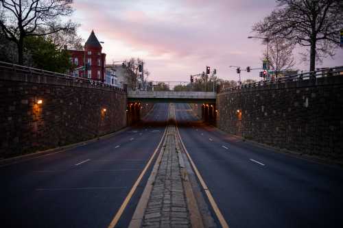
The COVID-19 pandemic and recession have initiated the most consequential transportation upheaval of our lifetimes. Stay-at-home orders, job losses, and public health fears have meant fewer vehicles on the road, a surge in e-commerce deliveries, frightening drops in transit ridership, and a genuine biking renaissance. They have also delivered the holy grail for many transportation planners: roadways without congestion.
Yet even as drivers enjoy free-flowing traffic, long-standing structural concerns in transportation remain. Decades of suburbanization and highway investment have stretched the distances between where people live and where they want to go. The result is a transportation system that is a top source of pollution and unintentional death, strains household budgets and public coffers, and gives consumers little transportation choice.
In other words, the pandemic has proved that solving congestion doesn’t solve our bigger transportation problems.
Overcoming those structural issues will require a new approach in how policymakers, planners, and other leaders design, build, and pay for our transportation networks and the neighborhoods they serve. Metropolitan American needs an approach focused on proximity and bringing people and places closer together. This means we can no longer make congestion our top priority; we need to build cities for shorter-distance travel.
Today’s structural problems have their roots in how we measure the performance of our transportation networks and prioritize faster vehicle speeds. Governments tend to use a system called “level of service” (LOS) to measure congestion, which isn’t too dissimilar from the color-coded traffic indicators in a GPS map app. Essentially, LOS delivers higher scores for roads where traffic can more frequently reach posted speed limits. Transportation analysts then use LOS results to judge where to make infrastructure investments and inform the kinds of congestion indexes that the media cites.
No one likes being stuck in traffic, but this congestion-focused approach is flawed from the start. LOS and congestion indexes fail to inform practitioners about where travelers start their trips, where they end those trips, or why they’re traveling in the first place. There is no recognition of the interplay between physical design and travel behavior, nor is there a recognition of broader economic, social, or environmental goals. And with Americans regularly wasting more time in traffic than ever before, the approach doesn’t even work.
Fortunately, new technology can support a new approach. The emergence of anonymized geolocation data allows practitioners and researchers to better track travel behavior at a regional and neighborhood scale, measuring exactly when, where, and how far people travel every day. The COVID-19 pandemic has been the grand demonstration of this data’s power: Media outlets worldwide have used geolocation data to demonstrate how many people were staying home, where people were congregating too much, and a host of other measures.
Using those same kinds of data, it’s now easier to compare trip distances across metropolitan America—and study how planning decisions impact people’s behavior.
In an October report, we analyzed travel patterns in six U.S. metro areas using geographically granular geolocation data (Table 1). Using a pool of 71.5 million daily trips, we found that the average trip in these six places spanned 7.3 miles and lasted 15.5 minutes. But it was also clear that metro areas with less congestion also force residents into longer-distance trips. It’s nice that Kansas City, Mo. drivers encounter less rush hour congestion than their peers in Portland, Ore., and that they save 2.5 minutes per trip—but they’re also likely to travel 1,600 more miles per year. Subsequently, Kansas City residents are likely to spend more money on gas and vehicle maintenance, consume more energy, and see their local governments devote more money to maintain more infrastructure. So who’s really winning?

Another advantage to geolocation data is it allows us to compare travel behavior among individual neighborhoods, which in our analysis totaled 5,257 census tracts. We cross-compared that enormous sample size with a wealth of geographic and demographic characteristics.
Subdividing these neighborhoods by their average trip distance offers two vital takeaways (Table 2). First, neighborhoods associated with longer-distance trips do enjoy faster travel speeds, but their total travel time is often longer. In other words, there’s little to no time savings to counterbalance all the extra miles traveled. Second, physical design matters: Neighborhoods with shorter-distance trips tend to have greater population densities, are situated closer to downtown, and contain more intersections—all features of more proximity-focused designs.

Comparing two specific neighborhoods can visualize the relationship between physical design and local travel behavior. For example, Chicago’s Logan Square neighborhood—which was designed for pedestrians and transit use, not cars—ends up having much shorter trips than a suburban peer like Roselle, Ill., which filters traffic to a highway and other wide roads.

Considering these findings, metropolitan planners, elected officials, and other partners should want to create more neighborhoods like Logan Square. Neighborhoods designed at this scale are more socially inclusive, more environmentally resilient, require less infrastructure per capita, and are safer for all. Our findings also reveal why chasing congestion reduction is a fool’s errand: Communities will lose many benefits of proximity while mostly failing to give residents shorter travel times.
Practitioners at all levels of government need a new approach to performance measurement, one that will help build more proximity-focused neighborhoods and downplay the importance of congestion reduction. We recommend any performance measurement suite include three key guiding principles:
- Practitioners should use anonymized geolocation data to accurately measure travel behavior at the neighborhood scale and make inter-neighborhood comparisons.
- Practitioners should build accessibility indexes to measure the number of key destinations someone can reach by multiple modes within certain distances and times.
- A database should include a broad range of complementary datasets—industry location data, sidewalk quality, property values, etc.—to compare how infrastructure supply, neighborhood conditions, and travel behavior interrelate.
Some of this work is already underway. California is now testing a transition to a “vehicle miles traveled” (VMT) measurement scheme to replace LOS. Many other cities and states have general VMT reduction targets. Even if there’s no example of a complete implementation of a new measurement approach, practitioners are moving in the right direction and emerging data will make it possible.
The COVID-19 pandemic and recession will not last forever—and once they’re over, it’s reasonable to expect that congestion will return. When that happens, we must resist the urge to keep trying to “solve” congestion. Instead, let’s address the inequities that existed before COVID-19. Connecting people to opportunity, reducing our fossil fuel use, and saving everyone money are benefits too good to ignore.
Related Content
Authors


The Brookings Institution is committed to quality, independence, and impact.
We are supported by a diverse array of funders. In line with our values and policies, each Brookings publication represents the sole views of its author(s).

Commentary
We should design cities for shorter distances, not faster speeds
December 17, 2020