Environmental risks vary both among and within different economic corridors of the Belt and Road Initiative (BRI), China’s initiative to strengthen regional cooperation through infrastructure and investment. Identifying the most environmentally sensitive areas during the planning of transport routes can help avoid environmental damage while availing of economic benefits that come from the improved infrastructure. This blog, based on a new working paper, provides a simple framework and illustrations of how one environmental risk from the overland (“belt”) part of the BRI might be assessed.
A cursory evaluation of the distribution of forest cover change within these corridors has provided a preliminary indication of areas most vulnerable to one of the most consequential environmental risks: deforestation. Because satellite data of forest cover are not that difficult to obtain, forest cover loss (deforestation) is commonly used as a proxy for a range of environmental impacts on biodiversity, carbon storage, water provision, and other eco-services. Map 1, created by our colleague Andrew Jacobson, shows the forest cover in the BRI’s geographic realm.
Map 1. BRI transport projects and forest cover, loss, and gain

There are six main economic corridors of the belt component of the BRI (Map 2). Putting Maps 1 and 2 together indicates that deforestation risks are especially high in Southeast Asia. Looking more closely would reveal vulnerable areas along the other corridors as well.
Map 2. The BRI’s six main economic corridors
 Source: HKTDC
The different landscape settings
To assess deforestation risks along the BRI economic corridors, there are at least three landscape settings, which should be distinguished by their levels of prior development and prior forest loss:
- Landscape Setting 1: High deforestation and high prior economic development. In the most economically developed and often deforested regions, little natural forest remains to be cleared. Hence, minimal forest impact is expected from BRI transport projects within these areas. It is even possible that lowered transport costs could lead to rural transformations that results in reforestation, such as through tree plantations.
- Landscape Setting 2: Medium deforestation and medium prior development. In areas that have experienced intermediate levels of economic development and deforestation over the last 15 years, significant forest loss may be expected from BRI projects near existing forests.
- Landscape Setting 3: Low deforestation and low prior economic development. Where there has been little economic development and little prior deforestation, the immediate effects from BRI transport projects may be relatively small. These areas generally lack the conditions for rapid economic development, so short-term effects on forest cover may be minor. However, there is enormous risk and uncertainty concerning the long-term impacts. Should the projects trigger migration and complementary investments, forest clearing could become rampant over time.
Table 1. Risk of deforestation across landscape settings
| Landscape Setting | Deforestation Risk from Infrastructure Investments | Examples from BRI Economic Corridors | |
|---|---|---|---|
| High deforestation/ high prior development |
Forest-agriculture “mosaicland”: population densities are relatively high, markets close by, and deforestation rate high for the remaining natural forests | Less deforestation risk likely because of extensive forest loss already, given existing relatively low transport costs and high economic activity |
– Southwest China, parts of Cambodia (CICPEC) – Parts of Kazakhstan (CCAWAEC) – Bangladesh (BCIMEC) |
| Medium deforestation/ medium prior development | Frontier and disputed areas: pressures for deforestation and degradation high or increasing, and control often insecure and in conflict | Significant deforestation risk because these areas are where the frontiers of development are located and expanding |
– Myanmar, Laos, Malay peninsula (CICPEC) – Near Moscow (CMREC) – Southwest China, Bangladesh, parts of Cambodia (CICPEC) – Parts of Kazakhstan (CCAWAEC) |
| Low deforestation/low prior development | Areas beyond the agricultural frontier: substantial forest remains with few and largely indigenous inhabitants; some pressure on timber resources | In the short run, minimal risk of forest loss; in long run, potentially significant risk of forest loss if new transport generates profit that attracts labor and capital and increases production |
– Eastern Russia (CMREC) – Western Thailand (CICPEC) |
Where to worry, what to do
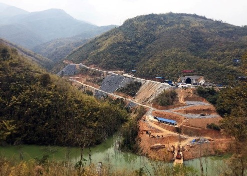
As described in Table 1, new road or rail access to frontier forests with “medium” prior development typically leads to the greatest absolute deforestation and eco-service losses, at least in the short term. These forests are close to infrastructure yet not cleared, and conditions are ripe for expansion of economic activities. The BRI high-speed rail project that traverses Laos (see photo) is a good example of these conditions, and has been flagged for potentially serious environmental impacts.
By comparison, transport access to “intact frontier landscapes” (large, undeveloped wilderness frontiers) does not spark much immediate deforestation, yet can result in future deforestation depending on the dynamics triggered by transport investment. Complementary mitigation policies to avoid losses, such as protected areas that flank roads or rail, may reduce long-term forest losses. Finally, new transport investments connecting major cities through cleared lands—that is, areas with “high” prior development—can pose little deforestation risk, and such investments might have the highest economic benefits.
Figure 1. Road/rail location tradeoffs

Heterogeneous environmental and economic impacts within and across BRI economic corridors makes it clear that it matters greatly where new roads and railways are built. Location determines whether a project has positive or negative net benefits, as shown in Figure 1. Integrated planning during the early stages of BRI economic corridor development makes it more likely that these details are considered.
Related Content
Authors


The Brookings Institution is committed to quality, independence, and impact.
We are supported by a diverse array of funders. In line with our values and policies, each Brookings publication represents the sole views of its author(s).

Commentary
The deforestation risks of China’s Belt and Road Initiative
January 28, 2019