Forests play an indispensable role in bolstering biodiversity, supporting a stable climate, and providing sustainable livelihoods. Yet, the earth is rapidly losing its forests. In the last 30 years, the world has lost 180 million hectares of forest—greater than the total area of Libya. Forests, especially tropical rainforests, are often cleared by illegal operators to acquire open land for large-scale farming and mining operations, which poses a serious threat to global efforts to reduce deforestation.
Early detection is a critical element of deforestation control efforts. Artificial satellites have played a crucial role here. Using regularly updated optical satellite data, such as LANDSAT, which captures the reflection of sunlight from the ground surface, several early warning systems (EWS) for deforestation have been launched since the 2000s to provide timely information on forest changes for regulators and civil society groups. EWS are now widely used in tropical countries to monitor forest protection. The Global Land Analysis and Discovery (GLAD) laboratory in the Department of Geographical Sciences at the University of Maryland maintains one EWS with publicly available deforestation data. Unfortunately, there is a severe drawback to optical satellite data. As we discuss in our chapter in the forthcoming book “Breakthrough: The Promise of Frontier Technologies for Sustainable Development,” detecting deforestation by optical satellites is substantially harder during the rainy season when cloud coverage is high. This is a serious problem because most of the illegal destruction takes place during the rainy season in the Brazilian Amazon to avoid detection, according to the Brazilian regulatory agency for illegal deforestation.
One solution is to use “radar eyes” in place of “optical eyes.” Radar satellites capture the image of the earth’s surface by catching the reflection of radar waves that the satellite itself generates. These waves can penetrate thick clouds, allowing researchers to identify whether trees exist on land regardless of cloud coverage. Japan’s ALOS-2 radar satellite, for example, can detect 1.5 to 10 times more deforestation than optical satellites during the rainy season in the Amazon area (November to March). Building on these technological advances, a new EWS called JJ-FAST (JICA-JAXA Forest Early Warning System in the Tropics), utilizing the ALOS-2 radar data, was launched in 2016 to provide data on deforestation in tropical countries.
While radar-based EWS can capture deforestation more timely and accurately during the rainy season, has it reduced tropical deforestation? To answer this question, we look at data from the Brazilian Amazon, the only county to date which has used radar-based EWS for deforestation monitoring. We hope that the quantitative evidence provided here will motivate other countries to employ this method to help combat deforestation.
Figure 1 conceptualizes how radar satellite EWS can help prevent deforestation. Suppose there are two forest areas of similar size in the Amazon. In the last three months, say February to April, Area 1 and Area 2 had the same amount of deforestation, measured by area, according to optical data (GLAD). However, images provided by radar data (JJ-FAST) indicate that Area 1 had more extensive deforestation than Area 2. When forest agencies analyze the data, Area 1 is likely to attract more attention, which means that the illegal operators in Area 1 face a higher probability of arrest, incentivizing illegal operators to stop logging and escape. As a result, the deforestation of Area 1 should be smaller in May. Therefore, if radar-based EWS reduces deforestation, there should be a negative correlation between the amount of deforestation detected by radar (JJ-FAST) and deforestation in the subsequent months.
Figure 1. Early warning systems and legal enforcement
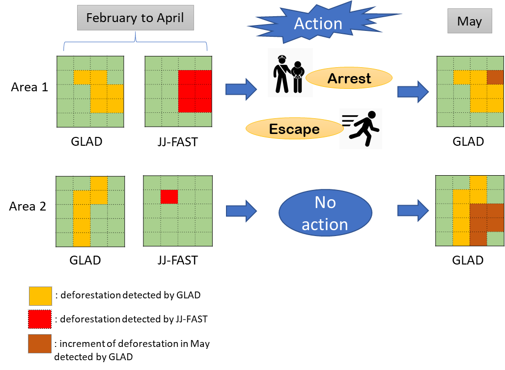
Source: Authors
Our data comes from three raster images covering the Brazilian Amazon in 2019—monthly radar data (JJ-FAST), monthly optical data (GLAD), and average monthly cloud cover.
Figure 2.1. GLAD Alerts raster image
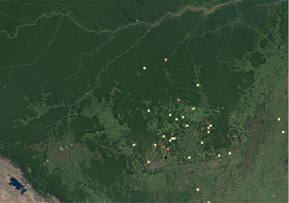
Figure 2.2. JJ-FAST raster image
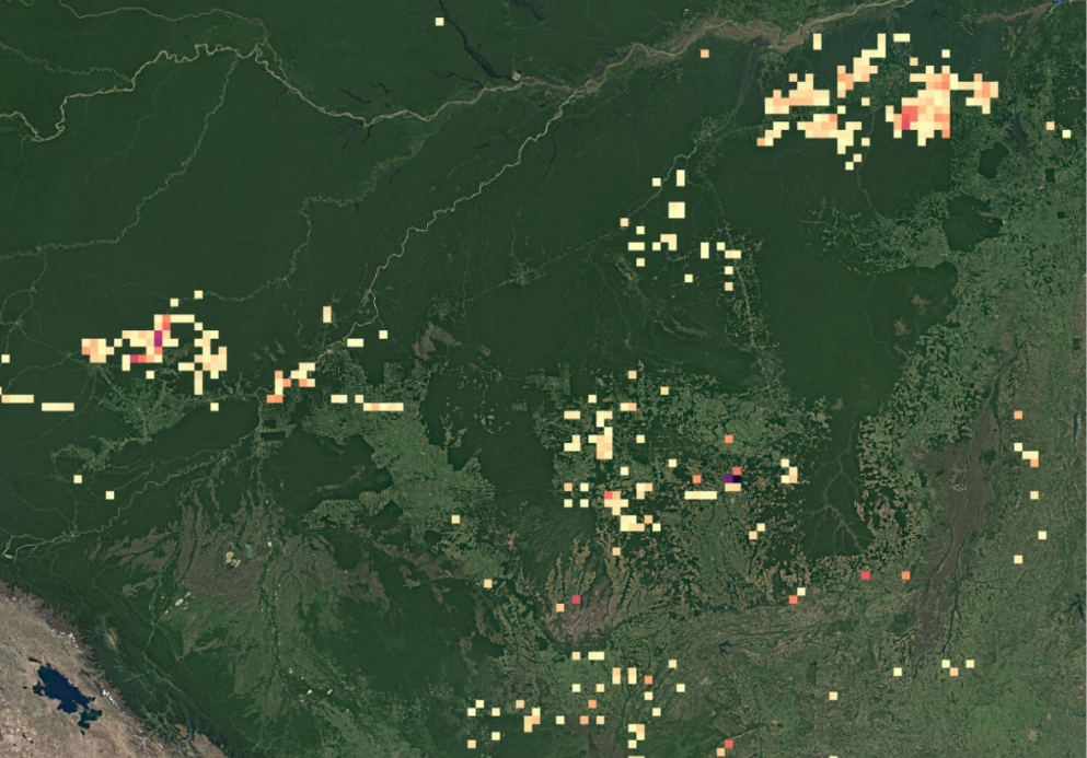
Note: Two images above show the raster data of deforestation by GLAD and JJ-FAST for the same part of the Amazon in February 2019 (rainy season). Cells with darker colors contain larger detected deforestations.
Source: Authors
To investigate whether we can observe a statistically significant negative correlation between the deforestation detected by radar satellite and the deforestation in the following month(s), we estimate the following equation using OLS (ordinary least squares):
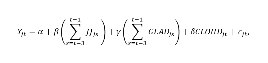
Where Yjt is the deforestation area in cell j in month t, reported by GLAD. JJjs is the deforestation detected by the JJ-FAST in the month of s in cell j. GLADjs is the deforestation recorded by GLAD. CLOUDjt is the cloud coverage. Our coefficient of interest is β, which is the correlation between JJ-FAST’s deforestation during three preceding months of t and Yjt. If β is negative and statistically significant, this means that the cells with higher deforestation recorded by JJ-FAST in the past three months have systematically lowered the deforestation record in the current month.
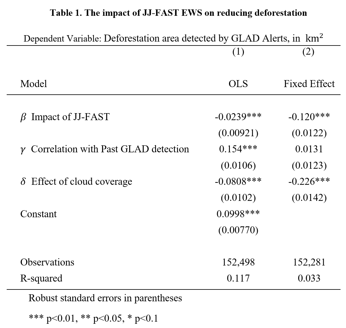
Table 1 reports the results. In sum, we observe that JJ-FAST monitoring significantly reduces deforestation in the Brazilian Amazon. The first column shows the results of the OLS estimation. As expected, the estimate on the effect of cloud coverage, δ, is negative and significant, indicating that higher cloud coverage is associated with a lower record of deforestation by GLAD. The estimate of β implies that a 1 km2 increase in deforestation, as detected by JJ-FAST, in the preceding three months reduces deforestation in the current month by 0.024 km2. To confirm the robustness of these results, we also report fixed effects results at the cell in the second column. With the fixed-effect estimation, the magnitude of the impact of JJ-FAST increases to 0.120.
Our quantitative investigation suggests that radar based EWS effectively reduces deforestation in the Brazilian Amazon. Although further analysis using data from other geographies is needed, our results highlight the important role new technologies can play in protecting global public goods.
The Brookings Institution is committed to quality, independence, and impact.
We are supported by a diverse array of funders. In line with our values and policies, each Brookings publication represents the sole views of its author(s).


Commentary
Protecting forests: Are early warning systems effective?
July 2, 2021