
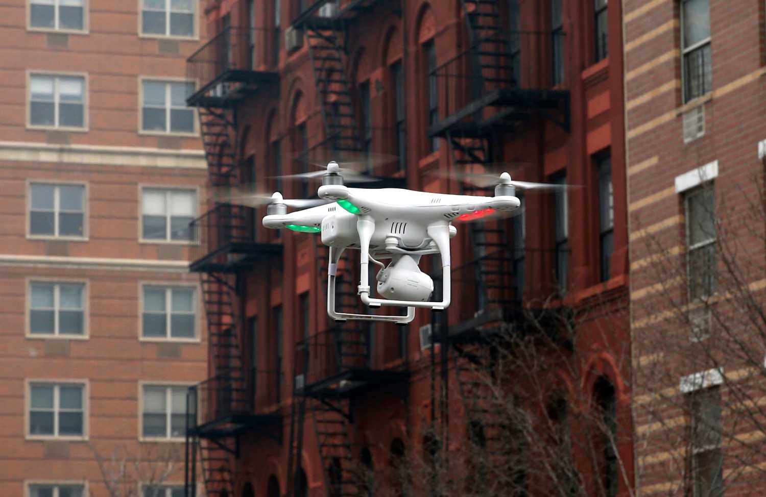
The looming prospect of expanded use of unmanned aerial vehicles, colloquially known as drones, has raised understandable concerns for lawmakers.1 Those concerns have led some to call for legislation mandating that nearly all uses of drones be prohibited unless the government has first obtained a warrant. Privacy advocates have mounted a lobbying campaign that has succeeded in convincing thirteen states to enact laws regulating the use of drones by law enforcement, with eleven of those thirteen states requiring a warrant before the government may use a drone.2 The campaigns mounted by privacy advocates oftentimes make a compelling case about the threat of pervasive surveillance, but the legislation is rarely tailored in such a way to prevent the harm that advocates fear. In fact, in every state where legislation was passed, the new laws are focused on the technology (drones) not the harm (pervasive surveillance). In many cases, this technology centric approach creates perverse results, allowing the use of extremely sophisticated pervasive surveillance technologies from manned aircraft, while disallowing benign uses of drones for mundane tasks like accident and crime scene documentation, or monitoring of industrial pollution and other environmental harms.
The first drone-related legislation appeared in 2013 in Florida, Idaho, Montana, Oregon, North Carolina, Tennessee, Virginia, and Texas.3 In 2014, Wisconsin, Illinois, Indiana, Utah, and Iowa also passed laws seeking to address the use of drones by law enforcement.4 As of the writing of this paper, the California legislature passed a drone-related bill that was vetoed by the governor, but the bill’s sponsors have vowed to revisit the issue in the next legislative session.5 These legislative efforts have been aimed at restricting the government’s use of drone technology, while largely allowing the government to conduct identical surveillance when not using drone technology. This absurd anachronism is intentional, as privacy advocates have explicitly chosen to capitalize on the public interest and attention associated with the demonization of drone technology as a way to achieve legislative victories. These advocates are admittedly not focused on more sensible legislation that addresses harms irrespective of the technology used.6
Privacy advocates contend that with drones, the government will be able to engage in widespread pervasive surveillance because drones are cheaper to operate than their manned counterparts. While drones are cheaper to operate, the drones most law enforcement agencies can afford are currently far less capable than their manned counterparts (oftentimes these drones are small remote controlled helicopters or airplanes, capable of a flight time of less than one hour). The surveillance equipment that can be placed on these drones is also far less intrusive than that which can be mounted to manned aircraft. Moreover, the term “unmanned aircraft” is also misleading as there are no systems currently available to law enforcement that can conduct fully autonomous operations, all systems need an operator for part of the mission. Thus, in almost all instances drones are less capable than manned aerial surveillance platforms, and while the platform is cheaper (but less capable), the personnel costs still remain constant as an officer is required to operate the drone. Granted, there are very sophisticated systems used by the military, but even if law enforcement agencies were able to afford the highly sophisticated multi-million dollar Predator and Reaper systems like those used for surveillance on battlefields, those systems (both the aircraft and the ground control station) are more expensive than manned helicopters, require a ground crew to launch and recover the aircraft, and require both a pilot and a camera operator. In light of these facts, the legislation being pushed by privacy advocates has been explicitly directed at drone technology, not because the technology represents an actual threat to civil liberties, but because someday in the future, the technology may be intrusive.7
To counter the threat of surveillance, privacy advocates have focused solely on requiring warrants before the use of drones by law enforcement. Such a mandate oftentimes will result in the grounding of drone technology in circumstances where law enforcement use of drones would be beneficial and largely non-controversial. For example, in light of the Boston Marathon bombing, police may want to fly a drone above a marathon to ensure the safety of the public. Under many bills, police would not be allowed to use a drone unless they had a warrant, premised upon probable cause to believe a crime had been or was about to be committed. This requirement exceeds current Fourth Amendment protections with regard to the reasonableness of observing activities in public places. What this means is that the police would need to put together a warrant application with sufficient facts to prove to a judge that they had probable cause. That application would need to define with particularity the place to be searched or the persons to be surveilled. All of this would be required to observe people gathered in a public place, merely because the observation was taking place from a drone, rather than from an officer on a rooftop or in a helicopter. In a circumstance like a marathon, this probable cause showing will be difficult for the police to satisfy. After all, if the police knew who in the crowd was a potential bomber, they would arrest those individuals. Rather, a marathon is the type of event where the police would want to use a drone to monitor for unknown attackers, and in the unfortunate event of an attack, use the footage to identify the perpetrators. This is precisely the type of circumstance where the use of drone could be helpful, but unfortunately it has been outlawed in many states. To make matters worse, this type of drone surveillance would pose little to no harms to privacy. A marathon is a highly public event, the event is televised, it takes place on streets where there are surveillance cameras and spectators are photographing the event. Moreover, in the states where drones have been banned (unless accompanied by a warrant), the police have not been prohibited from using any other type of surveillance equipment — just drones. This technology centric approach has done little to protect privacy, but will certainly harm public safety, depriving law enforcement of a tool that they could use to protect people.
While warrants are appealing to privacy advocates, the enactment of overly broad restrictions on drone use can curtail non-invasive, beneficial uses of drones. Legislators should reject a warrant-based, technology centric approach as it is unworkable and counterproductive. Instead, legislators should follow a property rights centric approach, coupled with limits on persistent surveillance, data retention procedures, transparency and accountability measures and a recognition of the possibility that technology may make unmanned aerial surveillance more protective of privacy than manned surveillance. This paper makes five core recommendations:
- Legislators should follow a property rights approach to aerial surveillance. This approach provides landowners with the right to exclude aircraft, persons, and other objects from a column of airspace extending from the surface of their land up to 350 feet above ground level. Such an approach may solve most public and private harms associated with drones.
- Legislators should craft simple, duration-based surveillance legislation that will limit the aggregate amount of time the government may surveil a specific individual. Such legislation can address the potential harm of persistent surveillance, a harm that is capable of being committed by manned and unmanned aircraft.
- Legislators should adopt data retention procedures that require heightened levels of suspicion and increased procedural protections for accessing stored data gathered by aerial surveillance. After a legislatively determined period of time, all stored data should be deleted.
- Legislators should enact transparency and accountability measures, requiring government agencies to publish on a regular basis information about the use of aerial surveillance devices (both manned and unmanned).
- Legislators should recognize that technology such as geofencing and auto-redaction, may make aerial surveillance by drones more protective of privacy than human surveillance.
Background
The domestic use of drones by law enforcement is a popular topic following passage of the FAA Modernization and Reform Act of 2012. The act directed that the FAA must integrate unmanned aircraft systems—drones—into the national airspace by September of 2015. A number of organizations have expressed concern over the possibility that thousands of drones will be crowding the skies, some armed with sophisticated cameras. The ACLU, for example, has been quite vocal in its criticism releasing a report that sets out their concerns over the prospect of intrusive aerial surveillance without proper safeguards. While a robust public debate over the use of domestic drones is warranted, the conclusion that widespread privacy violations are imminent is premature.
The conclusion that widespread privacy violations are imminent is premature.
While the FAA Modernization and Reform Act seeks the integration of unmanned aircraft into U.S. airspace by September 30, 2015, most of the provisions dealing with unmanned aircraft create a broad framework under which the FAA can explore the uses and feasibility of integration of this new technology. The key sections of the law direct the Secretary of Transportation and the Administrator of the FAA to draft plans, standards, and rules to ensure that drone integration proceeds in a safe and legal manner. In short, this is a public process where civil liberties and privacy groups will no doubt have a voice in crafting rules, and that voice seems to be at least as effective as the industry association’s voice. What is left out of the process is what state and local governments will do with the technology, and that is the primary focus of this paper.
Overview of Legal Issues
The Current State of Aerial Surveillance Law
Aerial observations of the curtilage of a home are generally not prohibited by the Fourth Amendment, so long as the government is conducting the surveillance from public navigable airspace, in a non-physically intrusive manner, and the government conduct does not reveal intimate activities traditionally associated with the use of the home. The U.S. Supreme Court addressed the issue of aerial surveillance in a series of cases in the late 1980′s:
In California v. Ciraolo8 the Supreme Court held, “The Fourth Amendment was not violated by the naked-eye aerial observation of respondent’s backyard.” In Ciraolo, the police received a tip that someone was growing marijuana in the backyard at Ciraolo’s home. A police officer attempted to observe what was growing, but his observations were obscured by a six foot high outer fence and a ten foot high inner fence. The officer, suspicious that the fences might be intended to hide the growth of marijuana, obtained a private plane and flew over the backyard of Ciraolo’s property at an altitude of 1,000 feet. That altitude was within the FAA’s definition of public navigable airspace. The Supreme Court found that this was not a search, and therefore was not prohibited by the Fourth Amendment. In so finding, Chief Justice Burger stated that in erecting a 10 foot fence, Ciraolo manifested “his own subjective intent and desire to maintain privacy as to his unlawful agriculture” but his “intent and desire” did not amount to an expectation of privacy. The Court noted that the fence “might not shield these plants from the eyes of a citizen or a policeman perched on the top of a truck or a 2-level bus.”9 Accordingly, “it was not ‘entirely clear’ whether [Ciraolo] maintained a ‘subjective expectation of privacy from all observations of his backyard,’ or only from ground level observations.”10 The Court believed that it was unreasonable for Ciraolo to expect privacy in his backyard when a routine overflight, or an observation “by a power company repair mechanic on a pole overlooking the yard” would reveal exactly what the police discovered in their overflight.11
They should not be required to ignore evidence of criminality merely because they witness the crime through the eyes of a drone.
At the same time that Ciraolo was decided, the Court held in Dow Chemical Co. v. United States that “the use of an aerial mapping camera to photograph an industrial manufacturing complex from navigable airspace similarly does not require a warrant under the Fourth Amendment.”
In Dow Chemical Co., the Supreme Court did acknowledge that the use of technology might change the Court’s inquiry, stating “surveillance of private property by using highly sophisticated surveillance equipment not generally available to the public, such as satellite technology, might be constitutionally proscribed absent a warrant.” But then the Court dismissed the notion, stating “[a]ny person with an airplane and an aerial camera could readily duplicate” the photographs at issue. In short, the Court stated, “taking of aerial photographs of an industrial plant complex from navigable airspace is not a search prohibited by the Fourth Amendment.”
In Ciraolo, the court had articulated a similar theme, noting that the defendant did not have a reasonable expectation of privacy in his backyard, despite having erected fences to obscure the yard from view. The Court reasoned that while the defendant shielded his yard from the view of those on the street, other observations from a truck or a two-level bus might have allowed a person to see into his yard. Continuing, the Court stated “The Fourth Amendment protection of the home has never been extended to require law enforcement officers to shield their eyes when passing by a home on public thoroughfares.” Despite the defendant’s fence, the Court said “the mere fact that an individual has taken measures to restrict some views of his activities [does not] preclude an officer’s observations from a public vantage point where he has a right to be and which renders the activities clearly visible.” The police flew a small commercial airplane over Ciraolo’s land from “public navigable airspace” and did so “in physically nonintrusive manner.” Therefore, while the defendant may have expected privacy in his backyard, privacy from aerial viewing was not one that society was prepared to deem reasonable. The Court stated, “[i]n an age where private and commercial flight in the public airways is routine, it is unreasonable for respondent to expect that his marijuana plants were constitutionally protected from being observed with the naked eye from an altitude of 1,000 feet.”
Shortly after Ciraolo and Dow Chemical Co. the Supreme Court analyzed the use of helicopters for aerial surveillance. In Florida v. Riley, the Supreme Court held that “the Fourth Amendment does not require the police traveling in the public airways at an altitude of 400 feet to obtain a warrant in order to observe what is visible to the naked eye.”12 The Riley court found that the rule of Ciraolo controlled. Riley, just like Ciraolo, took measures that “protected against ground level observation” but, “the sides and roof of his greenhouse were left partially open” just as the sky above Ciraolo’s yard allowed one to look directly down into his yard. In Riley, the police flew a helicopter over Riley’s land, and observed marijuana plants growing in Riley’s greenhouse.
The Court in Riley found that “what was growing in the greenhouse was subject to viewing from the air.” The police conduct in Riley was acceptable because the police were flying in publicly navigable airspace, “no intimate details connected with the use of the home or curtilage were observed, and there was no undue noise, and no wind, dust, or threat of injury.” The Court continued, “[a]ny member of the public could legally have been flying over Riley’s property in a helicopter at the altitude of 400 feet and could have observed Riley’s greenhouse. The police officer did no more.” In an important passage, concurring in the judgment, Justice O’Connor noted “public use of altitudes lower than [400 feet]—particularly public observations from helicopters circling over the curtilage of a home—may be sufficiently rare that police surveillance from such altitudes would violate reasonable expectations of privacy, despite compliance with FAA air safety regulations.”
Thus, the law for at least the last 25 years has allowed the police to fly aircraft over private property, backyards, factory farms, industrial plants, and any other place where the average citizen may fly a Cessna. The police may make observations from the air, just like a person on a commercial flight inbound to an airport can look down and observe the yards of people below and just like a utility worker on a pole can look down into an adjacent yard. Armed with that information, the police can use it to get a warrant to go in on foot and investigate what they previously observed from a lawful vantage point (without a warrant). For more than two decades, the police have not been required to turn a blind eye to evidence of criminality merely because they observed it from the air, they similarly should not be required to ignore evidence of criminality merely because they witness the crime through the eyes of a drone.
The Current State of Airspace Rights
As the prior section indicated, the Supreme Court’s aerial surveillance jurisprudence makes reference to “public navigable airspace” or observations from “a public vantage point where [an officer] has a right to be.” By tying the Fourth Amendment’s protections to the location in airspace from which the surveillance was conducted, the Supreme Court has left open the possibility that low altitude surveillance may violate the Fourth Amendment. Importantly, the drones that law enforcement are most likely to acquire and operate are most effective at altitudes below 500 feet. Thus, drones are poised to disrupt settled Fourth Amendment jurisprudence, by operating in airspace which heretofore has not been the subject of case law or statutes.
To understand this emergent legal issue, it’s necessary to understand the unsettled nature of landowner’s rights in low-altitude airspace. In the 1946 case United States v. Causby, the Supreme Court analyzed the airspace rights of landowners.13 The Causby case involved chicken farmers whose farm was adjacent to a small municipal airport that the U.S. military began using during World War II.14 The military flights were so low (83 feet above the land and 67 feet above the Causby’s home) that the Causby’s chickens would be frightened by each overflight, fly into the wall of their chicken coop, and die.15 The Causby’s sued the federal government claiming that the government’s flights constituted a Fifth Amendment taking.16
The Supreme Court’s opinion, authored by Justice William Douglas, began by analyzing the ad coleum doctrine.17 That doctrine had its roots in common law jurisprudence dating back centuries to Cino da Pisoia’s declaration “Cujus est solum, ejus est usque ad coelum” which translated means “[to] whomsoever the soil belongs, he owns also to the sky.”18 The doctrine “assigned airspace rights based on ownership of the surface land situated immediately below the space…airspace held by landowners…theoretically extended indefinitely to the outer reaches of the heavens.”19 Justice Douglas, analyzing the ad coelum doctrine quickly dispensed with it, stating that it had “no place in the modern world.”20 Rather, Douglas said that a landowner owned “at least as much of the space above the ground as he can occupy or use in connection with the land.”21 If the government or any other party intrudes into that space, such intrusions should be treated “in the same category as invasions of the surface.”22 Such invasions could, in the right circumstances, be treated as a trespass and on the facts presented by Causby the flights could be considered a compensable taking. The facts of Causby importantly involved flights that were “so low and so frequent as to be a direct and immediate interference with the enjoyment and use of the land.” The Causby opinion thus created two types of airspace, the public navigable airspace, a “public highway” in which the landowner could not exclude aircraft from flying, and the airspace below that which extends downward to the surface, in which landowners held some right to exclude aircraft.
This discussion brings into focus the possibility that a landowner may exclude others from entering the low altitude airspace above their property, and as such may exclude drones (whether government or civilian operated) from entering that airspace. But, if such rights in fact exist, at what altitude are such property rights triggered? Unfortunately there is very little clarity on this point. The Supreme Court referred to this airspace as the “immediate reaches” above the land, into which intrusions would “subtract from the owner’s full enjoyment of the property.”23
This graphic illustrates the complexities associated with the jurisprudence and regulations governing aerial surveillance and airspace rights. FAA regulations create a minimum altitude of 500 or 1000 feet in some areas (exempting helicopters from those minimums in certain circumstances). Those regulations also create a maximum altitude of 400 feet for model aircraft (which would include some drones). The Supreme Court in Ciraolo [GM1] approved aerial surveillance from manned aircraft flying at 1,000 feet, and in Riley approved aerial surveillance from a helicopter at 400 feet; however in Causby the Supreme Court said flights at 83 feet while taking off from an airport violated the Causby’s property rights. The average two story home is 35 feet tall, the question mark depicts the gray area which this paper argues must be clarified.
The lack of clarity presents a significant issue of law and public policy as the drones that are most likely to be operated by law enforcement (and citizens) are small planes and helicopters that are most effective when used below navigable airspace, that is to say, below 500 feet (although 500 feet is a rough rule of thumb).24 Consider the Supreme Court’s opinion in California v. Ciraolo, central to the Court’s holding was the notion that government surveillance from 1,000 feet above the ground took place from a “public vantage point” where a police officer had “a right to be.”25 But if the officer in Ciraolo were to conduct that surveillance today, with a drone, he would likely not fly the drone up to 1,000 feet, in fact he would likely fly it just high enough above the landowner’s property to look down and observe the marijuana plants, likely under 40 feet in altitude. Would such a flight violate the landowner’s reasonable expectation of privacy? It would largely depend on how obscured the land was from other observations at the same altitude. It would also require that the landowner have a right to exclude the drone from flying over their property. Of course such an exclusionary right would not prevent the officer from flying the drone above public land, such as the street. In such a circumstance the officer would need only stand on the sidewalk and fly the drone to an altitude high enough to see into the landowner’s property. Whether such a low altitude aerial observation above public land, peering into private property, would be considered a public vantage point and therefore acceptable from a Fourth Amendment perspective is similarly an open question.26
In Riley, the plurality said the case was controlled by Ciraolo,27 in her concurring opinion, Justice O’Connor presciently highlighted the problems with the Riley (and by extension the Ciraolo) Court’s opinion. She wrote:
Imagine a helicopter capable of hovering just above an enclosed courtyard or patio without generating any noise, wind, or dust at all and, for good measure, without posing any threat of injury. Suppose the police employed this miraculous tool to discover not only what crops people were growing in their greenhouses, but also what books they were reading and who their dinner guests were. Suppose, finally, that the FAA regulations remained unchanged, so that the police were undeniably “where they had a right to be.” Would today’s plurality continue to assert that “[t]he right of the people to be secure in their persons, houses, papers, and effects, against unreasonable searches and seizures” was not infringed by such surveillance? Yet that is the logical consequence of the plurality’s rule.”28
Analyzing this passage, Professor Troy Rule notes “[t]wenty-five years after Riley, law enforcement agencies can now easily purchase the very hypothetical ‘miraculous tool’ that O’Connor forebodingly described.”29 It’s not clear that such devices can be “easily purchase[d],” at least not yet. The small drones police are likely to purchase today cannot operate without creating noise and are incapable of seeing what books people are reading. Interestingly, Justice O’Connor was discussing manned aircraft, and manned aircraft do in fact possess the capabilities she feared. Yet we have witnessed very few proposals seeking to ban the use of high powered cameras mounted to helicopters or airplanes.30 Given the lack of interest in banning those capabilities from manned aircraft, it’s difficult to see why banning drones (which do not yet possess such capabilities) is a rational policy choice. Nevertheless, if engineers can continue to increase the lift capacity of drones, and can miniaturize the superior technology already mounted on manned aircraft, drones may eventually possess the capabilities Justice O’Connor feared. At that point it may be prudent to legislate with an eye towards controlling those observations (irrespective of whether they are from a drone or a manned platform).
More important than the future observational capabilities though, are the locational capabilities drones currently possess, namely the ability to hover “just above an enclosed courtyard.” At those lower altitudes, the drones that law-enforcement agencies are most likely to acquire become highly capable—and problematic. Thus the question of what exactly is the publicly navigable airspace has become increasingly critical to resolving how to deal with aerial surveillance. State and local governments do not need to wait on the FAA to define such areas. In fact, through zoning laws, state and local governments can clearly define the rights of landowners in the airspace above their land, in so doing they will answer many of the open questions regarding public vantage points.
Recommendations To Address Drones And Aerial Surveillance
This section is divided into two parts. The first part is a series of five “core recommendations” which, if adopted, will address most public and private harms associated with drones while balancing the rights of private parties and the needs of law enforcement. The second part consists of a series of principles that legislators should remain cognizant of if they choose to forgo the core recommendations and follow the problematic warrant-based approach advanced by some advocacy groups.
Core Recommendations
 Legislators should follow a property rights approach to aerial surveillance, explicitly extending to property owner’s rights in their airspace up to 350 feet above ground level. Such an approach may solve most public and private harms associated with drones by allowing the landowner to exclude intrusions into their airspace by government and private parties.
The uncertainty associated with landowner rights in the airspace immediately above their property has raised two problems. First, there is little clarity regarding where low altitude aerial surveillance by the government would violate the Fourth Amendment. Is it at 500 feet if by a fixed wing aircraft, or 1,000 feet?31 Is it 400 feet if by a helicopter? In Riley the Court said that the surveillance conducted at 400 feet by a helicopter did not require a warrant, but it left open the possibility that surveillance at a lower altitude would be acceptable. Thus raising the question, what about a flight at 350 feet? The case law on whether this would be a lawful observation is not clear, but it’s difficult to see how a court applying the principles of Riley would find substantive differences from an observation at 350 feet versus one at 400 feet. That’s because the Supreme Court’s jurisprudence tells us to look at whether the observation took place from “navigable airspace” or from a vantage point at which a member of the public could otherwise be. For helicopters, navigable airspace could easily include 350 feet above ground level, so long as the pilot was not creating a hazard.32 For drones and model aircraft, FAA rules and guidelines for hobbyists require operation below 400 feet, thus an operation at 350 feet would be from a public vantage point. The problem is not the technology, the problem is the ability of landowners to exclude aerial observations from certain vantage points (that’s a property rights problem). Any legislative solution for aerial surveillance must address this issue. Second, the absence of clarity with regard to property rights has also raised concerns about the privacy implications of private (non-government) uses of drones. While private drone use is beyond the scope of this paper, the right to exclude the government from conducting aerial surveillance is inextricably tied to whether the public would have had a right to make the observation the police made. The linkage of these two concepts suggests that a property rights approach may provide a way to harmonize these separate policy concerns and also address most of the concerns associated with aerial surveillance.
Property law is almost exclusively governed by state and local laws. Arizona State law professor Troy Rule—one of the first scholars to analyze property rights in the context of drones—- notes, “[u]nlike the murky set of legal rules governing low altitude airspace, the laws delineating property rights in the surface land could hardly be clearer.”33 The land, Professor Rule explains, is owned and those owners have rights to exclude trespassers and other intruders. However, “[t]he commons regime that governs high-altitude airspace is in many ways the antithesis of the private property regime that applies to surface land: no one owns high-altitude space, and everyone is welcome to use it if they follow certain rules.”34 In between the land and high altitude airspace is an area that is murky, and largely undefined. State and local governments can act to clarify the rights of landowners in the zone between the land and high altitude airspace.35
State and local governments that act to craft laws clarifying property rights in low altitude airspace could do so by arguing that they are merely codifying long standing property law doctrine. In so doing, state and local governments could rely on the Causby court’s declaration that “the flight of airplanes, which skim the surface but do not touch it, is as much an appropriation of the use of the land as a more conventional entry upon it… [such flights] are in the same category as invasions of the surface.”36
If low altitude flights immediately above a landowner’s property are akin to walking onto that property, then police who fly drones at low altitude above a landowner’s property to observe the backyard of a person’s home have engaged in conduct akin to walking onto that property. The Fourth Amendment analysis would require analyzing whether the landowner could have excluded the public from making an observation from that vantage point (i.e. did the flight take place in an area where the public had a right to be). Thus to control these low altitude flights, legislators will need to craft statutes that provide property owners with the right to exclude members of the public from this low altitude airspace.
Granted a rule extending property rights in a manner to prevent low altitude flights directly over a landowner’s property won’t preclude the police from asking a neighbor if they can fly above their adjacent property to obtain a better vantage point, just like existing rules don’t preclude the police (or a private citizen) from asking a neighbor if they can come inside to look out a second floor window into neighboring property. Similarly, such a rule won’t preclude the police from flying above public land (such as sidewalks and streets), but local zoning laws could address flights over public land. This proposed approach will preclude the police from flying at low altitudes directly over a greenhouse like the one in Riley or directly over a backyard like that in Ciraolo, but it would preserve the ability of the police to conduct those already lawful surveillance activities at or near the altitudes at which they were conducted in Riley (above 400 feet) and Ciraolo (above 1,000 feet). Such an approach would also have the secondary effect of making low altitude paparazzi drone flights unlawful when flown for example, directly above Kim Kardashian and Kanye West’s home.37
Legislators should follow a property rights approach to aerial surveillance. This approach provides landowners with the right to exclude aircraft, persons, and other objects from a column of airspace extending from the surface of their land up 350 feet above ground level (AGL).
What might such a statute look like? To preserve privacy, the landowner’s right must extend high enough to make the exclusion effective. However to preserve a right of transit for an Amazon or Google delivery drone, a mapping and real estate drone, or model aircraft, the right of exclusion cannot extend all the way up to the navigable airspace line (500 feet in most locations, 1,000 feet in congested areas).38 An appropriate statute would thus state that landowners own the airspace above their property up to 350 feet above ground level. In most locations that will provide the landowner with airspace rights that extend to more than ten times the height of the average two story home. By virtue of owning this column of land up to 350 feet, the landowner will have a right to exclude the general public (and therefore the police) from flying above their property in a way that will interfere with their enjoyment of the land. This proposal draws the line at 350 feet because while navigable airspace is generally understood as existing at a minimum altitude of 500 feet, the FAA has promulgated regulations and guidance which allow for the use of model aircraft (which includes drones) at altitudes up to a maximum of 400 feet (thus leaving a 100 foot buffer space between model aircraft operations and navigable airspace).39 Setting the landowner’s airspace at 350 feet provides a 50 foot buffer space between the ceiling of the property owner’s airspace and the ceiling of model aircraft airspace, allowing for a small transit zone for model aircraft. Such a transit zone may allow model aircraft operators to traverse the airspace above private property without fear of violating the landowner’s property rights, while simultaneously avoiding violating FAA regulations.
This proposal creates, from 350 feet upwards to navigable airspace, a buffer zone in which drones and other aircraft can fly (up to the established limit). In between the 350 foot ceiling of the landowner’s airspace and the floor of publicly navigable airspace (500 or 1,000 feet) drones could otherwise operate to transit over a landowner’s property en route to delivering goods. This also means that drones could even operate in this space to take photographs or conduct surveillance. But, while such surveillance may at first blush seem problematic, this proposal is in fact a nearly status quo solution. Under Riley, a warrantless helicopter observation from 400 feet was deemed constitutional, with the Court leaving open the possibility that observations from lower altitudes might also be constitutional. Thus, this proposal provides greater protections than those in Riley by providing greater precision. This proposal creates a bright line rule at 350 feet, making it clear that any aerial intrusion at or below that altitude would violate the landowner’s property rights and therefore would be a non-public vantage point. Thus, while drones and helicopters might still conduct surveillance at 350 feet, drone surveillance at that altitude will be far less intrusive than helicopter surveillance at 400 feet because a helicopter’s larger size enables it to carry far more sophisticated surveillance equipment; concomitantly observations from drones at 350 feet will be far less intrusive than observations from helicopters flying at the same altitude.40
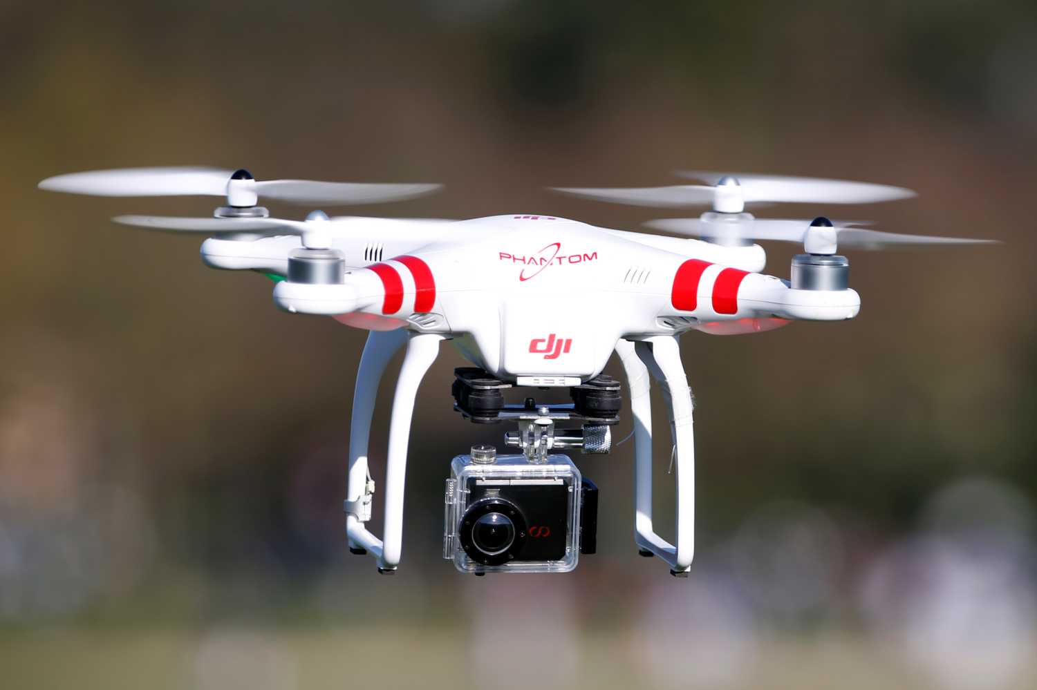
This image shows what a commercially available ($1,300) drone equipped with an HD camera sees at 350 feet altitude. The red arrow points to the drone operator. Some drones can carry cameras with zoom lens capabilities, however those systems are more expensive, larger, and louder. Those systems are also universally less capable than manned aircraft, which can carry heavier and more sophisticated surveillance equipment. (Photo credit: NPR http://www.youtube.com/watch?v=2zT1f_k0qRQ ).
Defining property rights in this manner (extending them up to 350 feet) will allow courts to readily adjudicate claims that an aerial observation violated the Fourth Amendment. A court’s inquiry into whether an officer had a right to be in the place where they made the observation, or whether the police observation was from a public vantage point will turn on this question “Did the police observation take place from a vantage point that violates the landowner’s right to exclude?” To answer that question, a court need only look to the statute and facts associated with the observation. With drones, those can be readily discernible as most law enforcement drones carry sophisticated GPS software that pinpoints their location. The salutary effect of this approach is that civil suits for unlawful operation of drones above a landowner’s property by voyeurs and other onlookers will be adjudicated with reference to clearly defined property rights, allowing courts to evaluate trespass and other claims.41
This proposal is not intended to ban aerial surveillance, rather it is intended to place aerial surveillance from drones and manned aircraft on equal legal footing; in that sense it is a status quo solution that is technology neutral. This proposal also ensures that policymakers remain focused on the harms of aerial surveillance, not the platform. Thus, if future law enforcement agencies begin using blimps (also known as aerostats), manned aircraft equipped with sophisticated cameras, or drones, in a manner that appreciably increases the current amount of aerial surveillance, policymakers can address those new technologically-enabled harms, rather than focusing merely on drones.
 Legislators should craft simple duration based surveillance legislation that addresses the potential for “persistent surveillance.”
To address the concern that the property based approach will allow drones or other aircraft to sit in the buffer airspace between the property owner’s airspace and publicly navigable airspace, legislators should focus on controlling the duration of surveillance. Doing so will limit two feared harms; first, duration based limits on aerial surveillance will address the possibility that drones or other technologies will enable the police to follow individuals and monitor their day to day activities. Second, duration based limits will address the possibility that drones or other aircraft will be used to hover directly above a landowner’s property for lengthy periods of time monitoring an individual’s day to day activities. These two forms of persistent surveillance can be conducted with manned or unmanned aircraft, therefore legislators should take a technology neutral approach to the problem, placing limits on the duration of surveillance rather than on the platform from which the surveillance can be conducted.
Crafting legislation that places aggregate limits on how long law enforcement may surveil specific persons or places can protect against the possibility of persistent surveillance. For example:
- Surveillance of a person may continue for 60 minutes at the officer’s discretion.
- 60 minute to 48 hour surveillance may only take place with a court order and reasonable suspicion.
- Surveillance of longer than 48 hours is permissible only when accompanied by a warrant and probable cause.42
The specific amount of time legislators may settle on (and the period of aggregation) will depend on whether a jurisdiction wants to value privacy or law enforcement efficiency. Note that the focus here is on surveillance of a specific person. If surveillance of widespread areas is occurring, legislators may want lengthier limits. For example, limiting aerial surveillance to 60 minutes unless accompanied by a warrant would mean that law enforcement could not monitor specific events such as the Boston Marathon. Such a limitation is likely not a desired policy outcome, and legislators should be careful to craft limitations in such a way that they address the harm of persistent surveillance (tracking of individuals) versus public safety (area surveillance) or event based surveillance.
Irrespective of the time chosen, the point is that carefully crafting duration based rules for surveillance (whether by drone, a manned aircraft, or otherwise) is a better approach than the current drone focused approach which is oftentimes riddled with blanket bans and exceptions.43 Rather than crafting special exceptions, legislating with an eye towards persistent surveillance rules based on clearly defined durational limits creates public policy that is clearer and easier to follow, easier for courts to adjudicate, and doesn’t allow for loopholes based on technology.
 Adopt data retention procedures that require heightened levels of suspicion and increased procedural protections for accessing data as time passes.
Many critics of drones raise the legitimate concern that the government’s collection of aerial imagery and video will enable pervasive surveillance that allows the government to know what all citizens are doing at all points in time, and even will allow government officials to review footage years after its collection, revealing the most intimate details about a person’s life. This is not a problem unique to drones, but is rather a recurring theme in critiques of all video and still imagery collection. Legislators should adopt policies that address collection and retention of information in a way that focuses on the information that is collected, how it is stored, and how it is accessed, rather than the particular technology used to collect the information. Thus, while this section speaks specifically about drones, the principles articulated here apply to all forms of video and imagery collection.
To protect against pervasive surveillance and warehousing of data about citizens, legislators should enact retention policies and procedures that make it more difficult for the government to access information as time passes. Eventually, information collected by the government should be destroyed at the end of a pre-determined period of time. While the specific duration of time and processes may be subject to debate, all procedures and timelines should be legislatively determined and therefore cannot be modified by individual agencies. To protect the rights of individuals, the information gathered and stored should be exempt from sunshine act requests, but should be fully discoverable in any criminal prosecution. A few process items will form the bulk of any responsible retention procedure:
- At the moment of collection up to 30 days after collection, information should be treated like any other contemporaneous or near contemporaneous observation. Agents of government should be able to monitor aerial surveillance in real time or near real time just as they observe CCTV’s in real time or near real time. This 30 day window will allow law enforcement to respond to immediate or nearly immediate complaints about violations of the law.
- After 30 days have passed from initial collection, information collected from aerial surveillance should be moved from servers openly accessible by law enforcement, to servers that are only accessible with a court order and a showing of reasonable suspicion.
- After 90 days have passed from initial collection, police should not be allowed to access information stored on servers without a court order and a showing of probable cause that indicates that the information contained on the servers contains evidence of a crime.
- All information stored on servers should be automatically deleted after a period of time so that the government does not maintain a long term archive of information about individuals. That period of time may be as short as 120 days, but should not be longer than five years.
 Legislators should adopt transparency and accountability measures, requiring government agencies to publish on a regular basis information about the sue of aerial surveillance devices (both manned and unmanned).
Transparency and accountability measures should be required regardless of whether legislators follow the core recommendations or the warrant-based principles (Part B. below). Transparency and accountability measures may be more effective than suppression rules or warrants for controlling and deterring wrongful government surveillance. To hold law enforcement accountable, legislators should mandate that the use of all aerial surveillance devices (manned or unmanned) be published on a regular basis (perhaps quarterly) on the website of the agency operating the system.
These usage logs should detail who operated the system, when it was operated, where it was operated (including GPS coordinates), and what the law enforcement purpose for the operation was. Legislators may even mandate that unmanned systems operated in their jurisdictions come equipped with software that allows for the easy export of flight logs that contain this information. Such logs will allow privacy advocates and concerned citizens to closely monitor how aerial surveillance devices are being used, enabling the political process as a mechanism to hold operators accountable.
In circumstances where publishing usage logs may reveal information that is law enforcement sensitive (such as an ongoing investigation) the agency operating the drone may keep their usage logs confidential until the investigation is closed. The agency should be required to make the logs public within 30 days of the close of an investigation. To facilitate public accountability legislators should mandate that all logs be published in an open and machine-readable format consistent with the President’s Executive Order of May 9, 2013.44
For evidence that this flight log approach works, one need only look across the Atlantic to the United Kingdom where many police departments publish their helicopter flight logs on their webpage; in fact some even live tweet their helicopter’s activities. While there is no law within the United Kingdom that specifically requires police departments or law enforcement agencies to publish the flight logs of their helicopters, their version of the Freedom of Information Act appears to be the legislative authority prompting publication of police helicopter logs.
Like the United States, there are a number of public watchdog groups in the United Kingdom that monitor police activity, including groups whose sole purpose is to monitor the activity (and related noise complaints) of police helicopters.45 These groups, and their respective websites, act as a forum for noise and privacy complaints from various individuals across the Kingdom, and several of these groups organize and lobby Members of Parliament (MPs) to pass legislation restricting helicopter flyovers.46 These groups, and the advocacy which they generate, appear to be largely responsible for the recent trend of many UK police departments publishing their helicopters’ flight logs, or even creating Twitter accounts for their helicopters that publish real-time or delayed-time updates of the aircraft’s activity.47
These helicopter Twitter accounts, which have become a growing trend amongst British police departments, have had an immediate and powerful effect on public relations in their respective jurisdictions. In Islington, the police department went from struggling to handle the overload of noise complaints relating to the department’s use of its helicopter to receiving no complaints after the creation of its Helicopter Twitter feed.48 The Twitter account gained over 7,000 followers after its first few weeks, and the public criticism of police helicopter activity ceased entirely. The department reflected on the effectiveness—as well as future potential—of the Twitter feed by issuing this statement:
Maybe that is all people wanted – just to know and understand what we were doing. We don’t update people in real time, but my vision is that soon we will be able to let people know about an operation as soon as it is over. In some cases we could get them to help – imagine if an elderly person with Alzheimer’s was missing in Islington, we could Tweet our followers to keep an eye out.
The Suffolk Police Department launched its Twitter feed with the hope of shedding some light on police practices. Roger Lewis, an observer with the Suffolk Police, described the department’s intentions in the following way:
We hope to use the Twitter feed to highlight the positive work being done by the Air Operations Unit and to keep members of the public informed as to why the helicopter has been deployed. We hope people will enjoy finding out more about the Unit and hopefully our tweets will give some explanation as to why we have been deployed and give some interesting insights into a very important policing tool.49
It is not difficult to see how the practice of disclosing non-sensitive flight logs through a public channel—such as a department web page or through Twitter—can be a useful tool in reassuring the public that law enforcement’s helicopter does not represent Big Brother’s eye in the sky, but rather embodies a part of the department’s lawful policing practices. Just as a police helicopter high overhead can be ominous to those on the ground who are unaware of its purposes, the very idea of drones—of any kind—flying above American cities and towns might be foreboding to many lay persons. By requiring law enforcement to publish data or logs, legislators can add a citizen-centric political check that will help quell the fears of a society that is not yet certain how it should react to the increasing presence of aerial surveillance devices over the skies of America.
 Recognize that technology such as geofencing and auto-redaction may make aerial surveillance by drones more protective of privacy than human surveillance.
Technology continues to evolve at such a rapid pace that it is possible drones and other aerial surveillance technologies may enable targeted surveillance that protects privacy, while still allowing for the collection of evidence. Technology can further the goal of privacy by using geofencing technology to only collect evidence from specific locations, and using redaction programming to automatically obscure information at the point of collection. Creative legislators can embrace technology by writing laws requiring that aerial surveillance devices have systems to protect privacy.
For example, imagine that the police receive a tip about marijuana growing in the backyard of 123 Main Street. They dispatch a helicopter to gather aerial photographs of the 123 Main Street property from an altitude of 700 feet. While the police are overhead photographing 123 Main Street, they look down and see a woman sunbathing in the adjacent property at 125 Main Street. While the inadvertent observation of the woman at 125 Main Street does not violate her Fourth Amendment rights, it may nevertheless be viewed from her perspective as an offensive intrusion that violates her personal expectation of privacy (even if it’s not one that society, per the courts, is willing to deem reasonable). Imagine the same collection scenario, this time conducted by a drone or a camera on a manned helicopter with software that is programmed to protect privacy. Prior to the mission the aircraft would be instructed to only document the activities ongoing at 123 Main Street. The software could be required to automatically redact any additional information gathered from adjoining properties (such as 125 Main Street, the home of our hypothetical sunbather). Furthermore, legislators could also require that software automatically blur the faces of individuals, with faces only being revealed upon an adequate showing of either reasonable suspicion or probable cause (the particular standard to be determined by the legislature) to believe that an individual is or was involved in criminal activity. If a state or local government required that aircraft engaged in aerial surveillance be coded for privacy, the rights of the adjacent sunbather and any other inadvertently observed individuals would be protected. If such policies were mandated, society may evolve to the point where drones are mandated when manned flights might place law enforcement officers in a situation where they might be tempted to make unwanted observations of innocent people. Thus, drones may someday be more protective of privacy than manned aircraft.
Alternate Recommendations and Principles
If legislators choose to ignore the core principles and approach articulated above, the following recommendations are intended to provide legislators with principles that will guide their policymaking in the more problematic warrant-based approach to drones and aerial surveillance.
Legislators should reject calls for a blanket requirement that all drone use be accompanied by a warrant.
If legislators forgo the property rights approach detailed in Part A. above, they should eschew proposals that require warrants for the use of drones. Such prohibitions are overbroad and ill-advised.50 Legislation that requires warrants for drones treats the information from a drone differently than information gathered from a manned aircraft, differently than that gathered by a police officer in a patrol car, or even from an officer on foot patrol. Under current Fourth Amendment jurisprudence, police are not required to shield their eyes from wrongdoing until they have a warrant. Why impose such a requirement on the collection of information by drones?
Much of the anti-drone activists efforts are aimed at the threat of persistent and pervasive surveillance of the population by the government, an understandable fear. But what is an unreasonable fear, and should not work its way into legislation, is a ban on ordinary aerial observations that are only controversial because they take place with a remote controlled helicopter rather than a manned one. If anybody in a Cessna can see the pollution pouring from a factory, or if the police flying in a helicopter can see a cartel’s drug operations or human trafficking ring — and such observations can be admitted as evidence in a criminal trial, shouldn’t citizens and the police be able to make the same observations and expect that the evidence won’t be excluded merely because it is collected with a remote control aircraft?
For example, imagine a police officer was on patrol in her patrol car. While driving, she witnesses the car in front of her strike a pedestrian and speed off. Until witnessing the crime she did not have probable cause (the predicate level of suspicion for a warrant), or even reasonable suspicion (the predicate level of suspicion for a brief investigatory stop) to believe the vehicle in front of her would be involved in a crime. Let’s further assume that her dash camera recorded the entire incident. Nonetheless, that dashcam video may be used as evidence against the driver in a subsequent criminal proceeding. However, under broadly worded proposals that have been introduced in many state legislatures and the U.S. Congress, the same piece of evidence if gathered by a drone would be inadmissible in court because police did not have a warrant.
Related Content
Consider another example. Police receive an anonymous tip that someone is growing marijuana in their backyard. A police officer attempts to view the backyard from the ground but his view is blocked by a 10 foot tall fence. The officer next decides to fly a commercially available remote controlled helicopter51 over the backyard and from a vantage point that does not violate FAA regulations observes marijuana plants growing in the yard. This observation would be unlawful under proposals that require a warrant for observations from a drone. However, these facts are nearly identical to the facts in the Supreme Court’s 1986 California v. Ciraolo52 decision which upheld aerial surveillance (discussed above). The only difference is that in Ciraolo, the officer flew over the backyard in an airplane, rather than using a drone. In fact, in Ciraolo the Court noted that not only would observation of the marijuana plants from the air (as described above) be lawful, police officers peering over the fence from the top of a police truck would also be behaving lawfully, and by extension, observation of the marijuana plants by police from the third floor of a neighboring home would also be lawful. But under proposals requiring a warrant for observations by a drone, this evidence would be inadmissible.
The examples above raise questions about what public policy goals are advanced by the suppression of evidence of a crime when documented by a drone, when the same evidence if recorded by a dashcam, observed from an airplane, or viewed from a neighboring home would be admissible in court. Such examples highlight the requiring warrants for evidence gathered by drones, when other methods of gathering the same evidence would not require a warrant.
Legislators should reject broadly worded use restrictions.
Some jurisdictions have enacted limitations on how information gathered from drones may be used. Legislators should reject these broadly worded use restrictions that prohibit the use of any evidence gathered by drones in nearly any proceeding. Such restrictions exceed the parameters of the Fourth Amendment and in some circumstances may only serve to protect criminals while not deterring governmental wrongdoing.
For example, the Alameda County California Sheriff’s Department proposed the use of small drones for: crime scene documentation, EOD missions, HAZMAT response, search and rescue, public safety and life preservation missions, disaster response, fire prevention, and documentation of a felony when such documentation is premised upon probable cause.53 Linda Lyle, a privacy advocate with the ACLU criticized the proposal, stating: “If the sheriff wants a drone for search and rescue then the policy should say he can only use it for search and rescue…Unfortunately under his policy he can deploy a drone for search and rescue, but then use the data for untold other purposes. That is a huge loophole, it’s an exception that swallows the rule.”54 Her points mirror the ACLU’s position in their December 2011 white paper where they state that drone use is acceptable so long as “the surveillance will not be used for secondary law enforcement purposes.”55 It is also similar to the language used in other proposals prohibiting the use of information gathered by a drone “as evidence against an individual in any trial, hearing or other proceeding….”56
A simple hypothetical can help to illustrate the problem with this approach. Imagine that law enforcement uses a drone to search for a lost hiker in a state park. This is a search and rescue mission that fits within the public safety, emergency, or exigency exceptions in most legislative proposals aimed at controlling drone usage. However, imagine that during the course of the search the drone observed a man stabbing a woman to death in the park. That collection was entirely inadvertent, and as such suppressing the videotape of the stabbing would not serve to deter the police from using drones in the future as they were not searching for an unrelated stabbing crime, they were searching for a lost hiker. Yet, that evidence under the blanket use restrictions found in various proposals circulating in state legislatures, Congress, and under the ACLU’s “secondary law enforcement purposes” standard would need to be suppressed.57
Suppressing secondarily gathered evidence doesn’t protect privacy (as inadvertent discovery can’t be deterred); it merely protects a criminal who if observed from a helicopter, an airplane, or from the ground would face evidence of his crime, but under broadly worded drone focused privacy bills may be more difficult to prosecute. It is difficult to see what public policy goal is furthered by suppressing evidence of a crime merely because the evidence was gathered from a drone instead of a helicopter. Do legislators really want to be in the position of making it harder to punish perpetrators of violent crime? If the discovery were genuinely inadvertent, there is little to no deterrent value that justifies suppressing such evidence.
If legislators choose to impose a warrant requirement, they should codify existing exceptions.
If legislators seek to impose a statutory warrant requirement on the use of drones, they should codify exceptions to the warrant requirement and exclusionary rule that the courts have developed through decades of jurisprudence. Such codification could either state that existing exceptions to the warrant requirement apply to the statutory requirement of a warrant, or the statute could enumerate the exceptions that should apply.
As the Supreme Court has noted, suppressing evidence has serious consequences for the “truth-seeking and law enforcement objectives” of our criminal justice system, and as such should present “a high obstacle for those urging [for its] application”58 it should be “our last resort, not our first impulse.”59 As such, the measure for when we should apply the exclusionary rule should not be whether a drone was used, but rather should be when “the benefits of deterrence…outweigh the costs.”60 Some exceptions and other procedural devices that legislators should consider codifying are:
- Rather than codify a blanket restriction on the use of any information gathered from a drone, legislators should codify a standing requirement that premises one’s ability to raise a suppression challenge on whether the person raising the suppression claim was the purported target of drone surveillance. Thus, if law enforcement uses a drone to document illegal dumping of toxic waste by Co-conspirator #1, non-present Co-conspirator #2’s privacy rights were not violated and #2 should not have the ability to vicariously assert #1’s privacy rights to protect himself from prosecution.
- Evidence gathered by drones should be admissible in proceedings short of trial such as grand jury proceedings,61 preliminary hearings,62 bail hearings,63 and other non-trial proceedings.
- Evidence gathered by drones should be admissible for impeachment purposes as there is little deterrent value in keeping such impeachment evidence out of a trial (as law enforcement is unlikely to gather it solely for that purpose) and the use of evidence gathered by drones for such a limited purpose furthers the truth-seeking process and deters perjury.64
- If legislators impose a statutory warrant requirement on the use of drones, it should also codify directly, or by reference the body of jurisprudence associated with the so-called good faith exception as articulated in United States v. Leon65 and Massachusetts v. Sheppard.66 The good faith exception allows for the admission of evidence gathered pursuant to a defective warrant, unless, based on objective facts, “a reasonably well trained officer would have known the search was illegal despite the magistrate’s authorization.”
- Legislators should make clear that the independent source doctrine as articulated in Murray v. United States applies equally to drone related surveillance.67 The independent source doctrine allows for the admission of evidence, despite police illegality, if the evidence seized was not causally linked to the illegal police conduct.
- Legislators should codify the inevitable discovery rule articulated in Nix v. Williams.68 In the context of drone surveillance, the rule would operate to allow the admission of drone gathered evidence in a criminal trial if the prosecutor can prove (by a preponderance of the evidence) that the evidence would have ultimately or inevitably been discovered by lawful means.69
- Rather than suppress all fruit of drone surveillance, Legislators should codify the attenuation principles articulated in Nardone and Wong Sun.70 The Court in Wong Sun stated that when considering whether fruit of an unlawful search should be suppressed, a court must ask “whether, granting establishment of the primary illegality, the evidence to which instant objection is made has been come at by exploitation of that illegality or instead by means sufficiently distinguishable to be purged of the primary taint.” Stated differently, at some point the fruit of the poisonous tree loses its potency. Factors Legislators should consider codifying are: 1) passage of time between the illegal search and the acquisition of evidence; 2) intervening events and a lack of foreseeability that the illegal drone surveillance would result in the gathering of evidence; 3) whether the initial illegal surveillance was a flagrant or deliberate violation rather than an accidental one.71
Legislators should carefully define terminology and specify what places are entitled to privacy protection.
If legislators choose to prohibit certain types of surveillance, such as prohibiting drone surveillance, the legislative drafting task will become more difficult and the task of defining terminology will be critical. What a layperson sees when they read the word search or surveillance, what a legislator means when they write it, and what a court may think the legislature meant are all different things. As such, when using terms like search, surveillance, reasonable expectations, curtilage, private property, public place and other terms of art, legislators should specify what the terms mean.
What a layperson sees when they read the word search or surveillance, what a legislator means when they write it, and what a court may think the legislature meant are all different things.
This definitional task will be the most important part of the legislative drafting process as the terminology will drive what actions are allowable and what places are entitled to privacy protection. Legislators should consider adopting an entirely new set of definitions, and be prepared to reject existing terminology which may be confusing. A good example of a well thought out definitional approach is the proposed legislation offered by Professor Christopher Slobogin.72 He uses the following terms:
- “Search: An effort by government to find or discern evidence of unlawful conduct. A targeted search seeks to obtain information about a specific person or circumscribed place. A general search seeks to obtain information about people or places that are not targets at the time of the search.”
- “Public search: A search of a place, in the absence of explicit consent, focused on activities or persons, limited to what the natural senses of a person on a lawful public vantage point could discern at the time of the search.”
- “Probable cause: An articulable belief that a search will more likely than not produce contraband, fruit of crime, or other significant evidence of wrongdoing…”
- “Reasonable suspicion: An articulable belief that a search will more likely than not lead to evidence of wrongdoing….”
Conclusion
The emergence of unmanned aerial vehicles in domestic skies raises understandable privacy concerns that require careful and sometimes creative solutions. The smartest and most effective solution is to adopt a property rights approach that does not disrupt the status quo. Such an approach, coupled with time-based prohibitions on persistent surveillance, transparency, and data retention procedures will create the most effective and clear legislative package.
Legislators should reject alarmist calls that suggest we are on the verge of an Orwellian police state.
Legislators should reject alarmist calls that suggest we are on the verge of an Orwellian police state.73 In 1985, the ACLU argued in an amicus brief filed in California v. Ciraolo that police observation from an airplane was “invasive modern technology” and upholding the search of Ciraolo’s yard would “alter society’s very concept of privacy.” Later, in 1988, the ACLU argued in Florida v. Riley that allowing police surveillance by helicopter was “Orwellian” and “would expose all Americans, their homes and effects, to highly intrusive snooping by government agents…” In a different context in 2004 (before the advent of the iPhone) police in Boston were going to use Blackberry phones to access public databases (the equivalent of Googling). Privacy advocates decried the use of these handheld phones as “mass scrutiny of the lives and activities of innocent people,” and “a violation of the core democratic principle that the government should not be permitted to violate a person’s privacy, unless it has a reason to believe that he or she is involved in wrongdoing.”74 Reactionary claims such as these get the public’s attention and are easy to make, but have the predicted harms come true? Is the sky truly falling? We should be careful to not craft hasty legislation based on emotionally charged rhetoric.
Outright bans on the use of drones and broadly worded warrant requirements that function as the equivalent of an outright ban do little to protect privacy or public safety and in some instances will only serve to protect criminal wrongdoing. Legislators should instead enact legislation that maintains the current balance between legitimate surveillance and individuals’ privacy rights. The best way to achieve that goal is to follow a property centric approach, coupled with limits on pervasive surveillance, enhanced transparency measures, and data protection procedures.
About the author
 Gregory McNeal is a professor at Pepperdine University and a contributor to Forbes. He is an expert in law and public policy with a specific focus on security, technology and crime.
Related Books

-
Footnotes
- For a lengthier discussion of these issues and an expanded analysis of the legal concepts discussed in this policy paper, See, Gregory S. McNeal, “Domestic Drones and the Future of Aerial Surveillance” available at: http://papers.ssrn.com/sol3/papers.cfm?abstract_id=2498116
- For a summary and analysis of the legislation, see Michael L. Smith, Regulating Law Enforcement’s Use of Drones: The Need For State Legislation available at:http://papers.ssrn.com/sol3/papers.cfm?abstract_id=2492374.
- FL. STAT. § 934.50 (2013), IDAHO CODE ANN. § 21-213 (2013), MONT. CODE ANN. § 46-5-109 (2013), OR. REV. STAT. § 837.310 et. seq. (2013), 2013 N.C. Sess. Laws. 1040, TENN. CODE ANN. § 39-13-609 (2013), TEXAS GOV. CODE ANN. § 423.002 (2013), 2013 Va. Acts 1408.
- WIS. STAT. § 175.55 (2014), 725 ILL. COMP. STAT. 167/10 et seq. (2014), IND. CODE § 35-33-5-9 (2014), UTAH CODE ANN. § 63G-18-103 (2014), IOWA CODE ANN. §§ 321.492B, 808.15 (2014).
- AB 1327: Unmanned Aircraft Systems California Legislative Information (August 22, 2014) http://leginfo.legislature.ca.gov/faces/billNavClient.xhtml?bill_id=201320140AB1327
- “The Rise of Domestic Drones” Radio Times With Mary Moss-Coane, at 42:20http://whyy.org/cms/radiotimes/2014/08/25/the-rise-of-domestic-drones/ (ACLU advocate stating “Ideally we would like to see broad legislation that covers all surveillance technologies, whether it is GPS, or phone tracking, or what have you. But if you go to state legislatures — and we have our lobbyists in state legislatures — and try and put forth a very very broad surveillance bill like that right now, it’s not going to go anywhere. We are fighting a large scale war here against surveillance and privacy and right now we have an opportunity to get in place some rules around drones because there is so much public interest and fascination with drones. And so we are pushing forward on that front.”).
- See generally, “The Rise of Domestic Drones” Radio Times With Mary Moss-Coane, at 42:20http://whyy.org/cms/radiotimes/2014/08/25/the-rise-of-domestic-drones/
- 476 U.S. 207 (1986).
- Id.
- Joshua Dressler, Understanding Criminal Procedure: Volume 1: Investigation, p.88-89, citingCiraolo.
- 476 U.S. 207, 214-15
- 488 U.S. 445 (1989)
- United States v. Causby, 328 U.S. 256 (1946).
- Id.
- Id.
- Id.
- Id.
- See Troy A. Rule, Airspace In An Age Of Drones, 95 Boston University Law Review __ (forthcoming 2015), 12 available at: http://papers.ssrn.com/sol3/papers.cfm?abstract_id=2482567, citing Stuart S. Ball, The Vertical Extent of Ownership in Land, 76 U. Pa. L. Rev 631 (1928), and Black’s Law Dictionary 453 (4th ed. 1968) noting that the full maxim reads “cujus est solum, ejus est usque ad coelum et ad inferos.”
- Troy A. Rule, Airspace In An Age Of Drones, 12.
- United States v. Causby, 328 U.S. 256 (1946).
- 328 U.S. 256, 264.
- Id. at 265.
- Id. at 264-266.
- While 500 feet is a useful rule of thumb for defining navigable versus non-navigable airspace, regulations governing navigable airspace are actually a bit more complex. Helicopters for example are exempted from minimum altitude regulations “if the operation is conducted without hazard to persons or property on the surface.” § 91.119(d). For fixed wing aircraft the rule is that over congested areas, the minimum altitude is 1000 feet above the highest obstacle within a horizontal radius of 2000 feet of the aircraft. § 91.119(b). For non-congested areas other than over open water or sparsely populated areas, the minimum is 500 feet. § 91.119(c). Over open water and sparsely populated areas, “the aircraft may not be operated closer than 500 feet to any person, vessel, vehicle, or structure.” See 14 C.F.R. § 91.119(b)–(c) (2012). Moreover, within certain distances of certain classes of airports and airspace altitude restrictions below 500 feet may also be in place.
- California v. Ciraolo, 476 U.S. 207, 213 (1986).
- Of course if such observations became frequent occurrences, legislatures could develop rules to govern such conduct.
- Florida v. Riley, 488 U.S. 445 (1989).
- Florida v. Riley, 488 U.S. 445, 462-463.
- Troy A. Rule, Airspace In An Age Of Drones, 20.
- See, “NYPD Helicopter Views Faces From Miles Away,” WIRED,http://www.wired.com/2008/06/nypd-helicopter/ (explaining how an NYPD helicopter “s flying over the skies of Manhattan allowing police to see and recognize a face from two miles away, peer inside a building from three to four miles away, and track a suspect car from 12 miles away.”).
- Notably, FAA regulations don’t clearly answer this question as the minimum altitude varies based on how congested an area is.
- See, 14 C.F.R. § 91.119 which reads:Except when necessary for takeoff or landing, no person may operate an aircraft below the following altitudes:(a) Anywhere. An altitude allowing, if a power unit fails, an emergency landing without undue hazard to persons or property on the surface.(b) Over congested areas. Over any congested area of a city, town, or settlement, or over any open air assembly of persons, an altitude of 1,000 feet above the highest obstacle within a horizontal radius of 2,000 feet of the aircraft.(c) Over other than congested areas. An altitude of 500 feet above the surface, except over open water or sparsely populated areas. In those cases, the aircraft may not be operated closer than 500 feet to any person, vessel, vehicle, or structure.(d) Helicopters, powered parachutes, and weight-shift-control aircraft. If the operation is conducted without hazard to persons or property on the surface— (1) A helicopter may be operated at less than the minimums prescribed in paragraph (b) or (c) of this section, provided each person operating the helicopter complies with any routes or altitudes specifically prescribed for helicopters by the FAA (emphasis added)
- Troy A. Rule, Airspace In An Age Of Drones, 29.
- Troy A. Rule, Airspace In An Age Of Drones, 27.
- Id. at 34 (making a similar argument, noting “state legislatures could…enact new laws that gave landowners clear rights to exclude drones or other aircraft from entering into the low-altitude airspace above their land up to the existing navigable airspace line…”).
- Causby 264-265.
- See, “Kanye West Is Totally Right To Worry About Paparazzi Drones”http://www.slate.com/blogs/future_tense/2014/08/07/kanye_west_fears_paparazzi_drones_that_s_totally_reasonable.html(noting West’s stated concerns [as recorded in a deposition] about drones “Wouldn’t you like to just teach your daughter how to swim without a drone flying? What happens if a drone falls right next to her? Would it electrocute her?” As for how that could happen, Kanye says, “Could it fall and hit her if that paparazzi doesn’t understand how to remote control the drone over their house?”). Limiting flights above private property, or property that is otherwise not accessible to the public could similarly prohibit flights like the reported drone flight above an LAPD impound lot that was otherwise obscured from view by a 16 foot wall, See “Don’t Fly Camera Equipped Drones Over Our Police Station, LAPD Says” http://arstechnica.com/tech-policy/2014/08/dont-fly-camera-equipped-drones-over-our-police-stations-lapd-says/ (noting police stating, “What concerns us is that they are filming over private property and it’s gated – you’re looking at the layout of the police station, how we operate, personnel license plates,” police Lt. Michael Ling said. “It’s kind of like if it was your house, if they’re flying over your backyard you’d start asking questions about it.”).
- For a contrary approach that extends the right to the public navigable airspace line, see Troy A. Rule, Airspace In An Age Of Drones, 35. ( “To preserve a level of privacy and safety comparable to what landowners enjoyed prior to the drones era, laws clarifying landowner airspace rights should define these rights as extending all the way up to the navigable airspace line of 500 feet above ground in most locations. A rule defining exclusion rights as covering only 100 feet or 200 feet above the ground would arguably be insufficient because it would allow small drones to cheaply hover above land and violate landowners’ privacy or threaten their safety from those altitudes… Because navigable airspace designations can vary by location, the exact heights of each parcel’s exclusion rights could initially be established based on the FAA’s existing navigable airspace designations.”).
- See, Interpretation of the Special Rule For Model Aircraft, available at:http://www.regulations.gov/#!documentDetail;D=FAA-2014-0396-0001, See also, FAA Fact Sheet- Unmanned Aircraft Systems, http://www.faa.gov/news/fact_sheets/news_story.cfm?newsId=14153 (stating “Recreational use of airspace by model aircraft is covered by FAA Advisory Circular 91-57, which generally limits operations to below 400 feet above ground level and away from airports and air traffic.”).
- To address the threat of pervasive surveillance whereby law enforcement might park a drone or other aircraft over a landowner’s property for extended periods of time, See Recommendation 2.
- States may need to update their trespass laws to address aerial trespass. For example, many jurisdictions define trespass as “entering on” or “remaining on” property, legislatures may need to clarify that property includes airspace.
- This is adapted in part from Slobogin at p. 24.
- To see the perils of a process riddled with exceptions, consider the bill passed by the Texas legislature which has no fewer than 22 exceptions for drone use with carve outs for agricultural interests, electrical companies, oil companies, real estate brokers and others).See HB 912, available at: http://www.legis.state.tx.us/BillLookup/History.aspx?LegSess=83R&Bill=HB912
- See, Executive Order — Making Open and Machine Readable the New Default for Government Information http://www.whitehouse.gov/the-press-office/2013/05/09/executive-order-making-open-and-machine-readable-new-default-government-
- See http://www.helicopter-noise.org.uk/;http://www.whatdotheyknow.com/request/issue_of_police_helicopter_fligh
- See http://www.parliament.uk/edm/2012-13/394 (proposed legislation to regulate/reduce the amount of noise pollution caused by nighttime police helicopter flyovers in London).
- Not all activity is published. The Cleveland (UK) Police Department’s website indicates that: “This page is intended to provide basic information to the general public regarding the work of the police helicopter and will be updated on a daily basis. Weekend and public holiday updates will appear on the next working day. Please note that not all items are always listed due to operational sensitivity or ongoing investigation.” http://www.cleveland.police.uk/news/helicopter-watch.aspx
- http://www.islingtongazette.co.uk/news/police_helicopter_twitter_account_stops_islington_complaints_1_1206725
- http://helihub.com/2012/09/03/uks-suffolk-police-helicopter-unit-now-on-twitter/
- For example, the “Preserving Freedom from Unwarranted Surveillance Act of 2012.”
- Perhaps a Parrot A.R. drone from the local mall’s Brookstone store, or a DJI Phantom bought on-line.
- 476 U.S. 207 (1986).
- Alameda County Sheriff’s Office, General Order 615 available at:http://nomby.files.wordpress.com/2013/02/small-unmanned-aircraft-system-general-order-6-15-draft.pdf
- Paul Detrick, “Cops with Drones: Alameda Co. CA Weighs Technology vs. Privacy” available at: http://reason.com/reasontv/2013/04/04/cops-with-drones-technology-vs-privacy
- “Protecting Privacy from Aerial Surveillance: Recommendations for Government Use of Drone Aircraft,” American Civil Liberties Union, December 2011, p. 16.
- For example, the “Preserving American Privacy Act of 2013” in Section 3119c creates a general prohibition on the use of covered information as “evidence against an individual in any trial, hearing, or other proceeding…” While the Act provides a set of exceptions, including one for emergencies, the language of the emergency exception as currently drafted does not clearly specify that inadvertent discovery of information unrelated to the emergency justifying the drone usage would be admissible, and it’s likely that defense counsel in such a case would seek to prohibit the admission of evidence in such a case by relying on the lack of a clearly specified exception.
- Id.
- Pennsylvania Board of Probation and Parole v. Scott, 524 U.S. 357, 364-365 (1998).
- Hudson v. Michigan, 547 U.S. 586, 591 (2006).
- Herring v. United States, 129 S. Ct. 695, 700 (2009).
- This is consistent with the Supreme Court’s approach to Fourth Amendment violations perUnited States v. Calandra, 414 U.S. 338 (1974). (noting that allowing “a grand jury witness to invoke the exclusionary rule would unduly interfere with the effective and expeditious discharge of the grand jury’s duties, and extending the rule to grand jury proceedings would achieve only a speculative and minimal advance in deterring police misconduct at the expense of substantially impeding the grand jury’s role.”).
- This is consistent with Congress’ guidance in Federal Rule of Criminal Procedure 5.1(e) which states in relevant part “At the preliminary hearing, the defendant may cross-examine adverse witnesses and may introduce evidence but may not object to evidence on the ground that it was unlawfully acquired.”
- See 18 U.S.C. 3142(f) noting the “rules concerning admissibility of evidence in criminal trials do not apply to the presentation and consideration of information at the hearing.”
- Contra James v. Illinois, 493 U.S. 307 (1990).
- 468 U.S. 897 (1984).
- 468 U.S. 981 (1984).
- 487 U.S. 533 (1988).
- 467 U.S. 431 (1984).
- Note, Nix was a Sixth Amendment case but courts have applied the fruits analysis to searches.
- Nardone v. United States, 308 U.S. 338 (1939) and Wong Sun v. United States 371 U.S. 471 (1963) respectively.
- See, Brown v. Illinois, 422 U.S. 590, 604 (1975).
- Christopher Slobogin, “Making the Most of United States v. Jones in a Surveillance Society: A Statutory Implementation of Mosaic Theory,” Duke Journal of Constitutional Law & Public Policy (forthcoming) available at: http://papers.ssrn.com/sol3/papers.cfm?abstract_id=2098002.
- Interestingly, Orwell seems to be a favorite citation for the ACLU who has cited him nearly 70 times in briefs.
- See Gregory S. McNeal, “Can The ‘Drone’ Industry Compete With The Privacy Lobby?” available at: http://www.forbes.com/sites/gregorymcneal/2012/08/13/can-the-drone-industry-compete-with-the-privacy-lobby/
The Brookings Institution is committed to quality, independence, and impact.
We are supported by a diverse array of funders. In line with our values and policies, each Brookings publication represents the sole views of its author(s).